Epstein ordered sulfuric acid on same day FBI opened probe. Files show mundane reason
Feb. 12th, 2026 04:00 pmSome social media users suggested the acid was to make bodies disappear.
Nestled among high snowy peaks in northern Italy, Cortina d’Ampezzo is hosting athletes in the 2026 Winter Olympics and Paralympics who are skiing, sliding, and curling toward a spot on the podium. The scenic mountain town is the co-host, along with Milan, of the international sporting extravaganza.
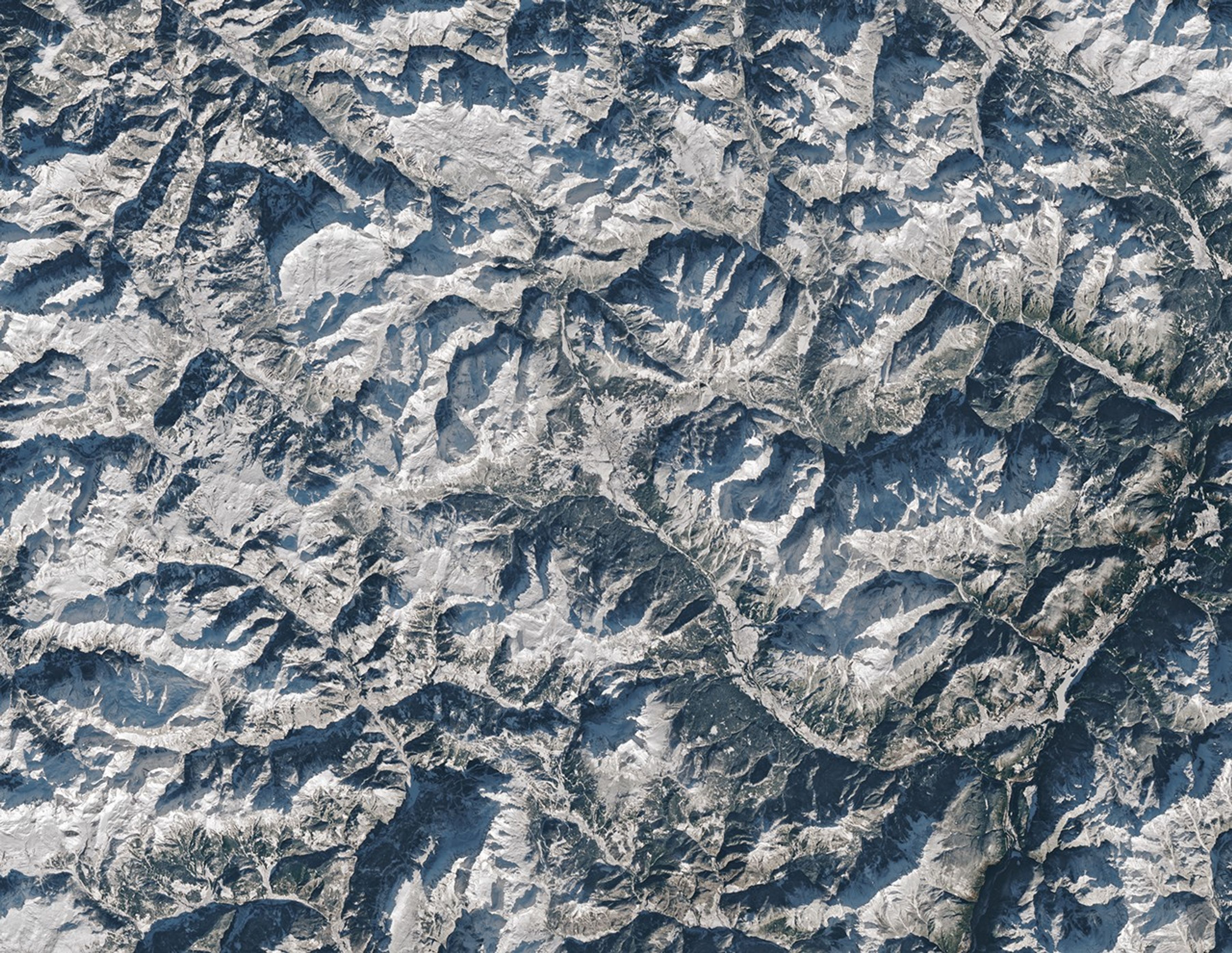
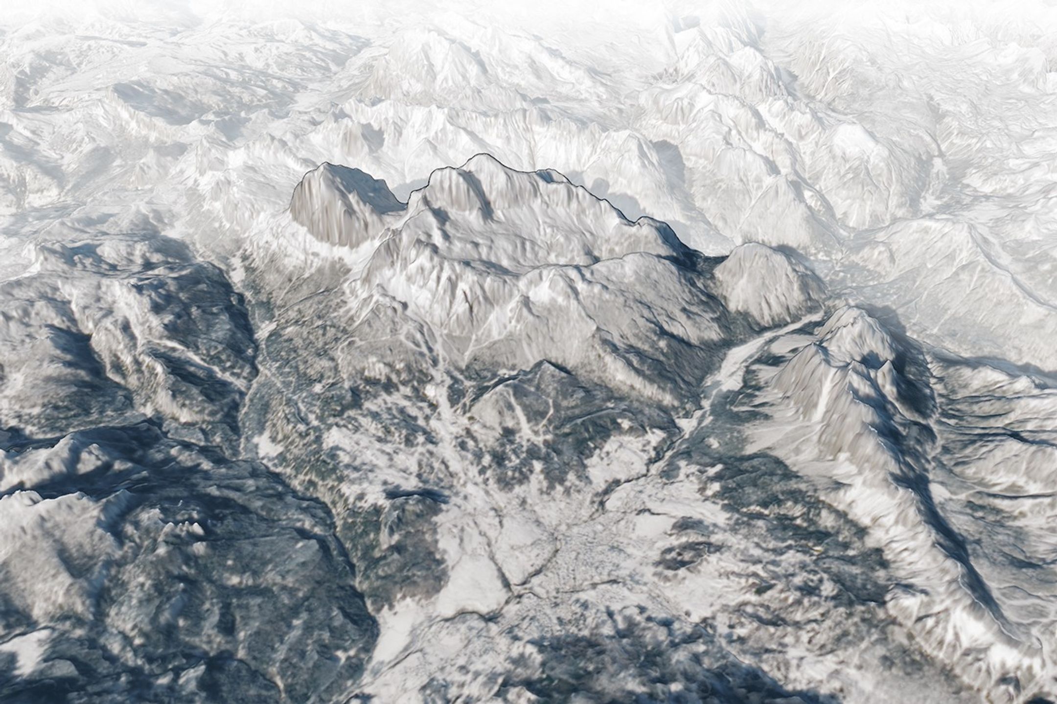
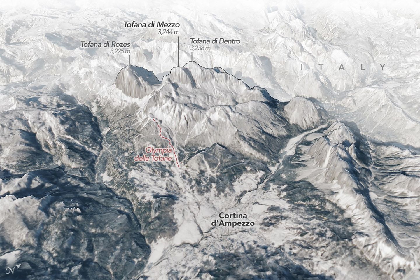
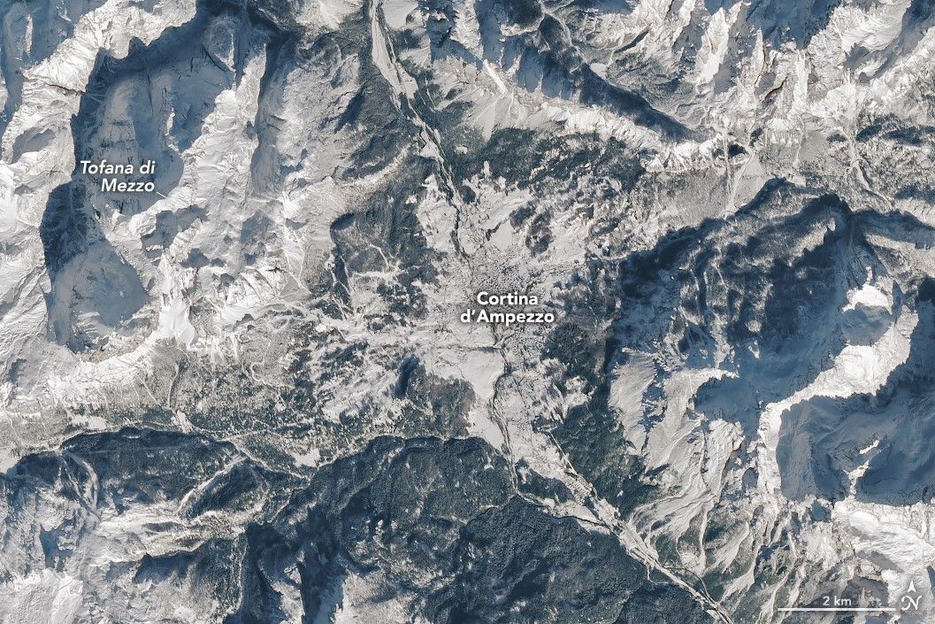
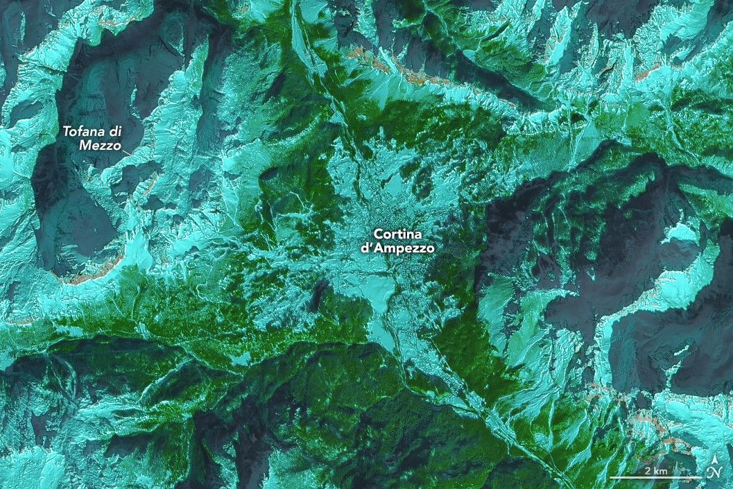
Cortina sits within the Dolomites, a mountain range in the northern Italian Alps known for its sheer cliffs, rock pinnacles, tall peaks, and deep, narrow valleys. In this three-dimensional oblique map, several peaks over 3,000 meters (10,000 feet) tall rise above the town. To create the map, an image acquired with the OLI (Operational Land Imager) on Landsat 8 on January 27, 2026, was overlaid on a digital elevation model.
Tofana di Mezzo, the third-highest peak in the Dolomites at 3,244 meters (10,643 feet), is the site of the Tofane Alpine Skiing Centre, the venue for the Olympic women’s Alpine skiing and all Paralympic skiing events. Competitors on the Olympia delle Tofane course descend 750 meters (2,460 feet), reaching high speeds and catching big air along the way. A highlight is the steep, 33-degree drop through the Tofana Schuss, a chute bounded by tall rock walls near the top of the course.
More adrenaline-filled races are taking place at the Cortina Sliding Centre, the venue for bobsled, luge, and skeleton events. Athletes are competing on a rebuilt version of the track used in the 1956 Olympics, hosted by Cortina. And curlers, trading speed for strategy, are going for gold at the Cortina Curling Olympic Stadium, built for the 1956 Olympic figure skating competition and opening ceremony. (There is indeed a theme: almost all of the 2026 Games are being held in existing or refurbished facilities.)


January 27, 2026
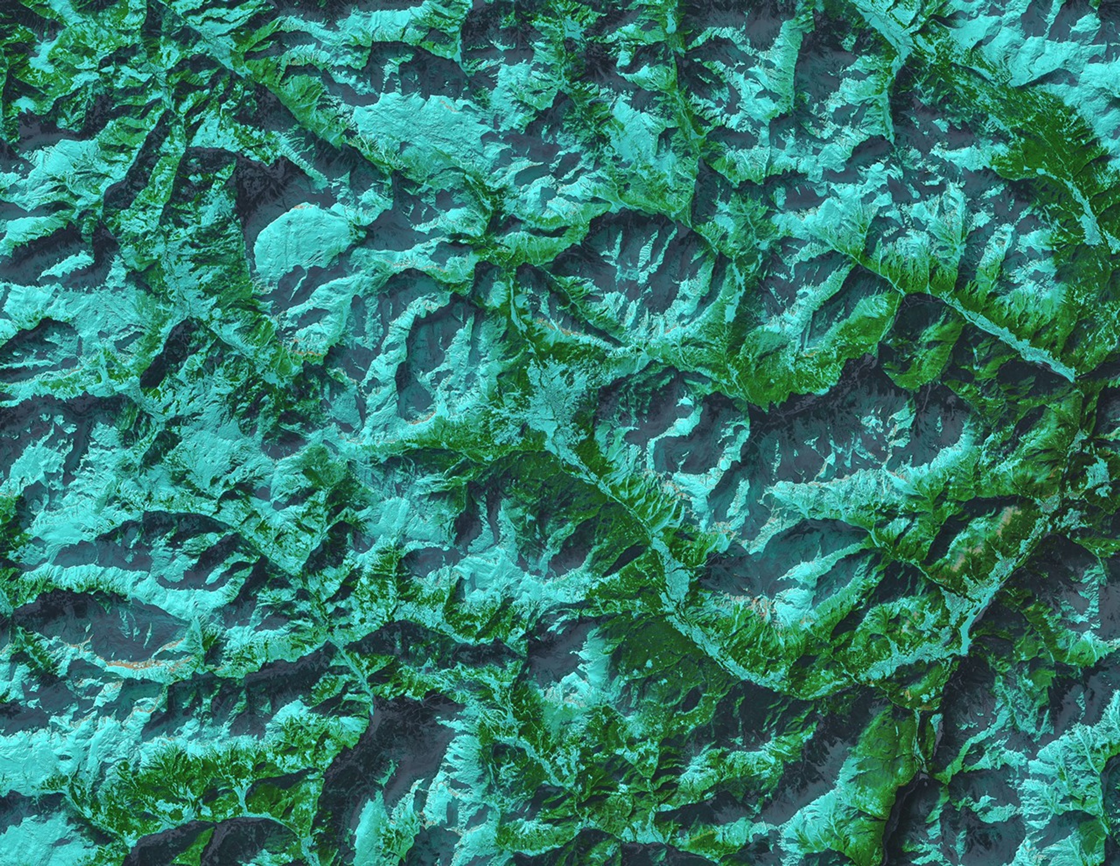
These Landsat images show Cortina and its surrounding alpine terrain in natural color and false color. The band combination (6-5-4) highlights areas of snow (light blue), while steep, mostly snow-free cliffs stand out as areas of light brown, and forests appear green.
Locations across the Italian Alps join Cortina in hosting the snow sports, which also include cross-country skiing, ski jumping, ski mountaineering, and snowboarding. As with many past Olympics, the 2026 Winter Games are manufacturing snow at the various venues to ensure consistent conditions. New high-elevation reservoirs were created to store water for snowmaking, according to reports. Automated systems are being used to limit snow production to the minimum amount required, and most snowmaking operations are being powered by renewable energy, the International Olympic Committee said.
Snowfall in northern Italy was below average at the start of the season, but a storm on February 3—three days before the opening ceremony—eased some of the need for snowmaking. Still, snow coverage and the ability of Winter Olympic venues to maintain consistent conditions are areas of concern as global temperatures rise. Researchers studying the issue have suggested several ways to address this, including holding competitions at higher elevations, choosing regional or multi-country hosts, and shifting the Paralympic Games from early March to January or February when it’s typically colder and snowier.
NASA Earth Observatory images by Michala Garrison, using Landsat data from the U.S. Geological Survey and elevation data from TINITALY. Story by Lindsey Doermann.
Stay up-to-date with the latest content from NASA as we explore the universe and discover more about our home planet.

About 2,900 Olympic athletes have converged on northern Italy to sort out who is the GOAT—or perhaps the stoat.

Very wet—but very warm—weather in the western U.S. has left many mountainous regions looking at substantial snowpack deficits.

Satellites observed a frozen landscape across much of the country after a massive winter storm.
The post Reaching Top Speed in the Dolomites appeared first on NASA Science.
While a part of the United States braved extreme winter cold, January 2026 brought sweltering summer conditions to many parts of Australia.
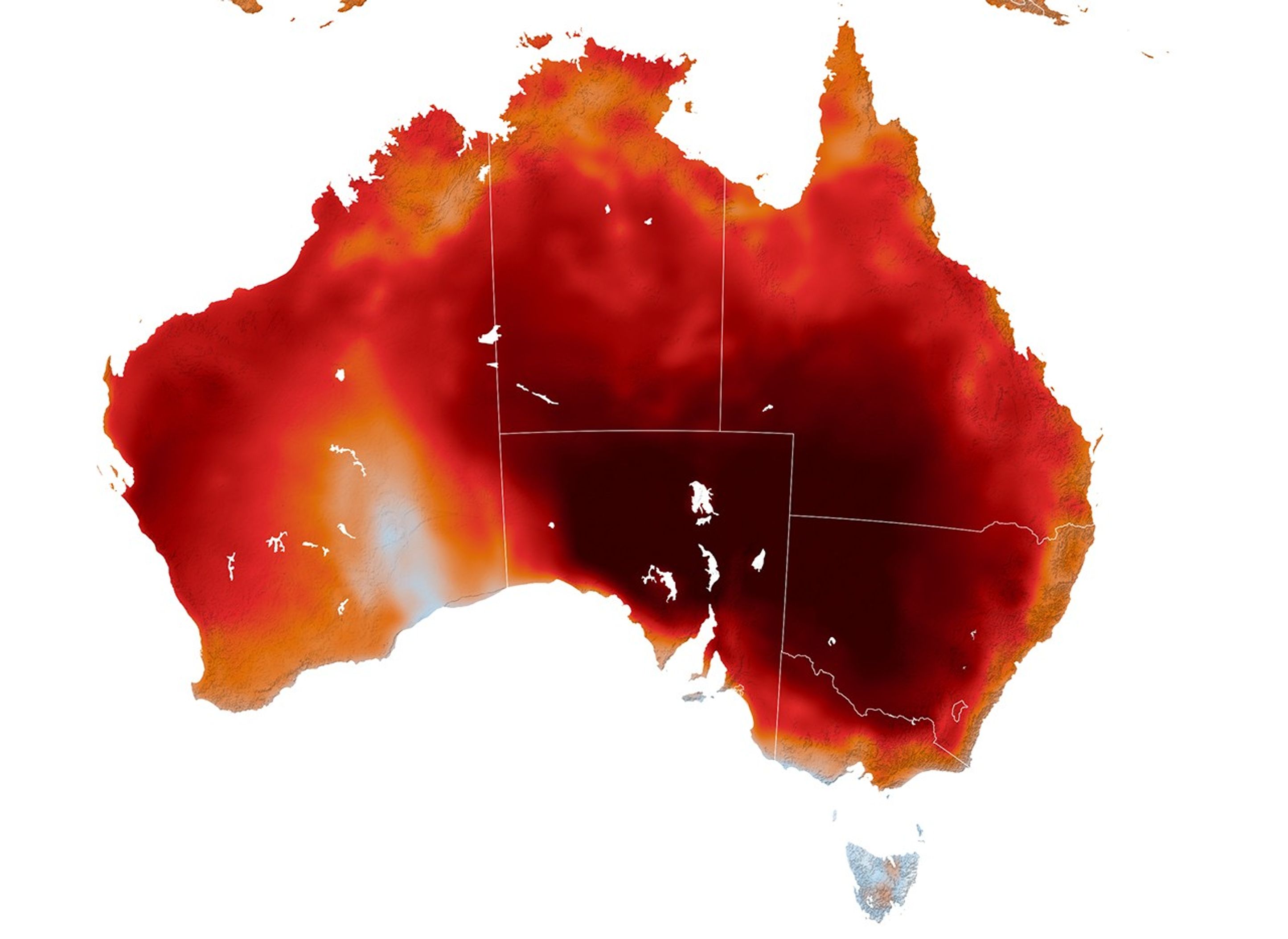
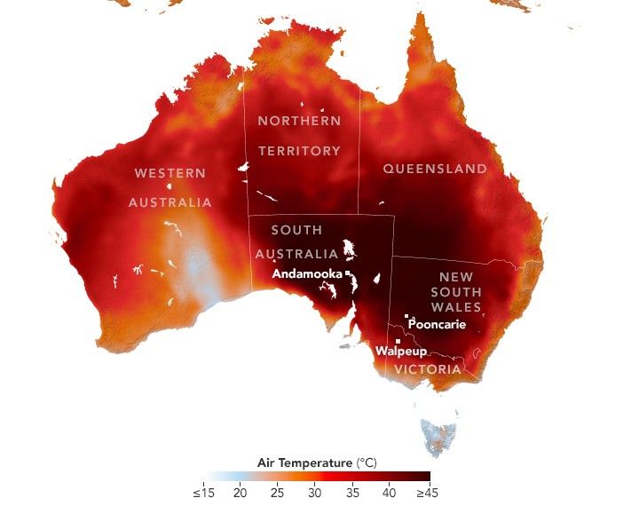
Australia’s area-averaged mean temperature was 1.90 degrees Celsius (3.42 degrees Fahrenheit) above the 1961–1990 average, making it the fourth-warmest January since the start of observations in 1910, according to the Bureau of Meteorology (BoM). Contributing to this was a late-month heatwave in the country’s southeast that was especially intense between January 26 and January 30. During that period, numerous weather stations in South Australia, New South Wales, and Victoria recorded record-high daily temperatures.
The heatwave’s intensity and extent are evident in this map, which shows air temperatures at 03:00 Universal Time (2 p.m. local time in Victoria) on January 29, modeled at 2 meters (6.5 feet) above the ground. It was produced with a version of the GEOS (Goddard Earth Observing System) model, which integrates meteorological observations with mathematical equations that represent physical processes in the atmosphere. The darkest reds are where the model indicates temperatures reaching or exceeding 45°C (113°F).
According to BoM, the hottest temperatures of January 2026 were measured in two places in South Australia: in the town of Andamooka on the 29th and at the Port Augusta airport on the 30th, where temperatures reached 50.0°C (122.0°F). In both New South Wales and Victoria, the month’s hottest day was on the 27th, when temperatures reached 49.7°C (121.5°F) at a station in Pooncarie and 48.9°C (120.0°F) at stations in Walpeup and Hopetoun.
The heatwave brought significant human and public-health effects, including the increased risk of heat-related illness. Organizers of the Australian Open tennis tournament in Melbourne, Victoria, suspended play on some courts and closed roofs to provide shade as part of an “extreme heat policy” to protect players and spectators, according to news reports.
The recent warmth followed another bout of heat earlier in the month that, combined with strong winds and dry conditions, created dangerous fire conditions. Numerous bushfires were burning across Victoria on January 9 as officials urged people to evacuate. By mid-month, news reports indicated that the fires had destroyed hundreds of structures and killed tens of thousands of livestock.
NASA Earth Observatory image by Lauren Dauphin, using GEOS data from the Global Modeling and Assimilation Office at NASA GSFC. Story by Kathryn Hansen.
Stay up-to-date with the latest content from NASA as we explore the universe and discover more about our home planet.

Following a significant winter storm, frigid temperatures lingered in late January 2026 across a vast swath of the U.S.

A prolonged high-pressure weather system brought unusually warm September temperatures to British Columbia and the Pacific Northwest.

Tens of thousands of people fled to safety as blazes spread throughout the country’s Biobío and Ñuble regions.
The post Summer Heat Hits Southeastern Australia appeared first on NASA Science.