Did Jesse Jackson's family bar Obama from funeral? Here's the truth
Feb. 20th, 2026 12:28 amWith the exception of a brief rift in 2008, the two publicly maintained mutual respect. A family representative told Snopes the rumor was false.
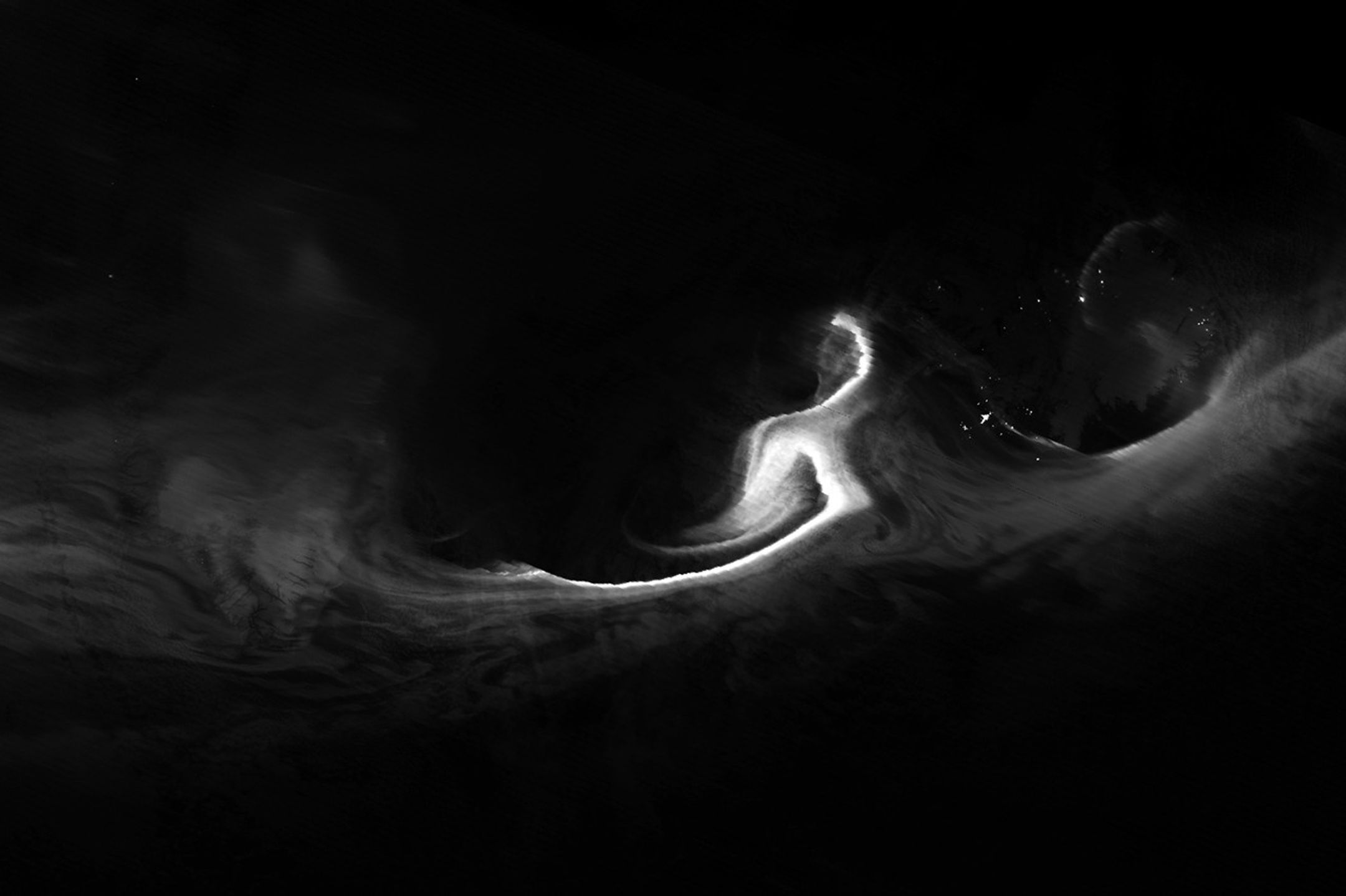
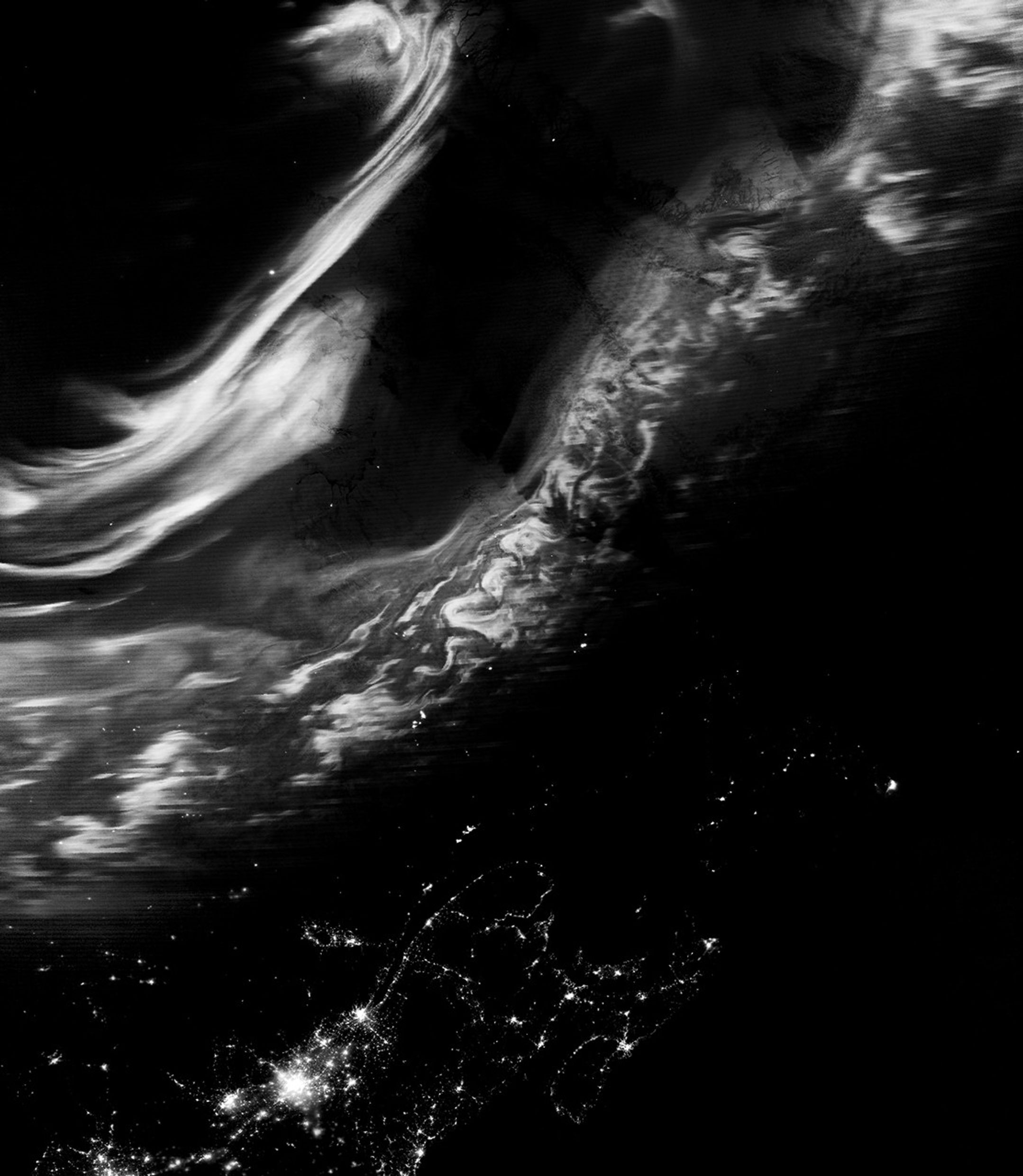
Although the aurora borealis, or northern lights, is most often observed in March and September, it can appear at other times of the year if conditions are right. For instance, in February 2026, a minor geomagnetic storm produced a striking display of light swirling across northern skies.
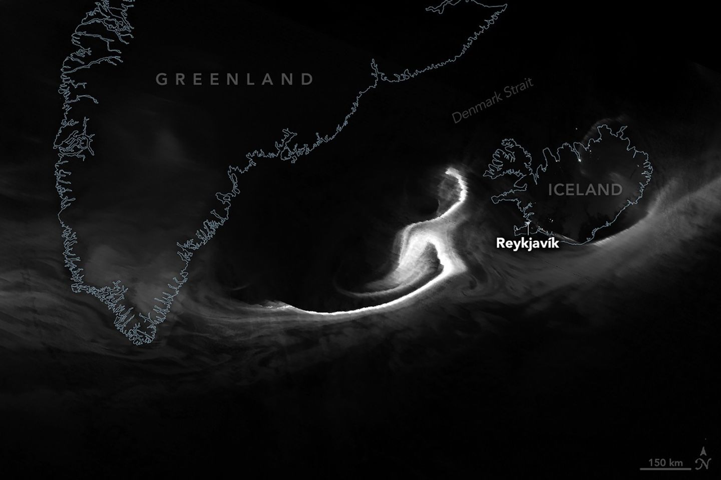
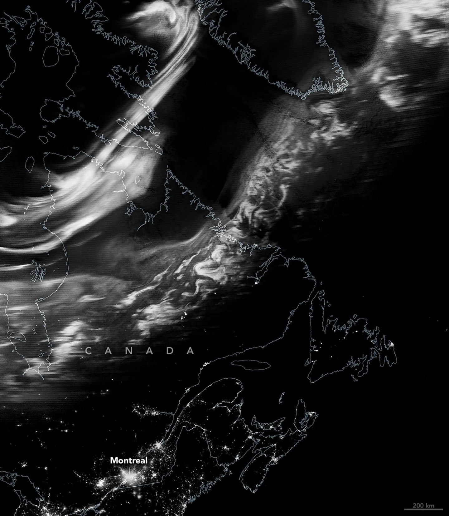
The VIIRS (Visible Infrared Imaging Radiometer Suite) on the Suomi NPP satellite acquired these images in the early morning hours of February 16. The VIIRS day-night band detects nighttime light in a range of wavelengths from green to near-infrared and uses filtering techniques to observe signals such as city lights, reflected moonlight, and auroras. While these satellite data are displayed in grayscale, auroras appear in various colors to observers on the ground, from green (the most common) to purple to red.
The first image (top) shows ribbons of light that shimmered over the Denmark Strait and Iceland at 04:45 Universal Time (4:45 a.m. local time in Reykjavík). The second image shows the view farther west, where the lights danced above the Canadian provinces of Québec and Newfoundland and Labrador at about 06:30 Universal Time (1:30 a.m. local time in Montreal).
According to the NOAA Space Weather Prediction Center, a minor geomagnetic storm was in progress during this period. Classified as a G1—the lowest level on a scale that goes up to G5—such storms typically make the aurora visible at high latitudes. G1 storms can also cause slight disruptions, including weak fluctuations in power grids and minor impacts on satellite operations.
Later that day, conditions intensified to a G2 storm, likely associated with a coronal hole and a high-speed stream of solar wind. G2 storms are considered moderate in strength and can occasionally push auroral displays as far south as New York and Idaho.
About a week earlier, on February 10, a NASA rocket mission launched from the Poker Flat Research Range near Fairbanks, Alaska, to study the electrical environment of an aurora. The GNEISS (Geophysical Non-Equilibrium Ionospheric System Science) mission’s two sounding rockets gathered data that will help scientists create a 3D reconstruction of the electrical currents flowing from the northern lights. Combined with observations from the ground and space, this information can help researchers better understand the system that drives space weather near Earth.
NASA Earth Observatory images by Michala Garrison, using VIIRS day-night band data from the Suomi National Polar-Orbiting Partnership. Story by Kathryn Hansen.
Stay up-to-date with the latest content from NASA as we explore the universe and discover more about our home planet.
The glow of city lights, the aurora, and a rising Moon illuminate the night along the northwest coast of North…

The Large Magellanic Cloud—one of our closest neighboring galaxies—is a hotbed of star formation that is visible to both astronauts…

An astronaut captured a moonrise—and much more—in a series of photos taken from the International Space Station.
The post Northern Glow Spans Iceland and Canada appeared first on NASA Science.
These images were part of the first successful use of a new technology called Mars Global Localization, developed at NASA’s Jet Propulsion Laboratory. Using its navigation cameras, NASA’s Perseverance captured a 360-degree view of the surrounding terrain that was matched to orbital imagery, enabling the rover to pinpoint its location on Mars on Feb. 2, 2026, the 1,762nd day, or sol, of the mission. The navcam images were turned into an overhead view called an orthomosaic, forming a circle around the rover. In this animation, the orthomosaic is superimposed on the imagery from NASA’s Mars Reconnaissance Orbiter (MRO). Contrast and hue have been enhanced to increase visibility of terrain features, which align in the ground and orbital imagery.
The rover took the five stereo pairs of navcam images in this relatively featureless location, dubbed “Mala Mala,” an area on the rim of Jezero Crater. The blank area in the upper right of the orthomosaic is where the back of the rover blocked the cameras’ view of the surrounding landscape.
Mars Global Localization features an algorithm that rapidly compares panoramic navcam shots to MRO orbital imagery. Running on a powerful processor that Perseverance originally used to communicate with the now-retired Ingenuity Mars Helicopter, the algorithm takes about two minutes to pinpoint the rover’s location to within some 10 inches (25 centimeters).
Like NASA’s previous Mars rovers, Perseverance tracks its position using what’s called visual odometry, analyzing geologic features in camera images taken every few feet while accounting for wheel slippage. As tiny errors in the process add up over the course of each drive, the rover becomes increasingly unsure about its exact location. On long drives, the rover’s sense of its position can be off by more than 100 feet (up to 35 meters). Believing it could be too close to hazardous terrain, Perseverance may prematurely end its drive and wait for instructions from Earth.
After each drive comes to a halt, the rover sends a 360-degree panorama to Earth, where mapping experts match the imagery with shots from MRO. The team then sends the rover its location and instructions for its next drive. That process can take a day or more, but with Mars Global Localization, the rover can compare the images itself, determine its location, and roll ahead on its pre-planned route.
Managed for NASA by Caltech, JPL built and manages operations of the Perseverance rover. JPL also manages MRO for the agency’s Science Mission Directorate in Washington as part of its Mars Exploration Program portfolio.
The post Mars Global Localization Pinpoints Perseverance’s Location appeared first on NASA Science.
Using its navigation cameras, NASA’s Perseverance Mars rover captured the five stereo pairs of images that make up this panorama on Feb. 2, 2026, the 1,762nd day, or sol, of the mission. A new technology called Mars Global Localization matched this 360-degree view to onboard orbital imagery from the agency’s Mars Reconnaissance Orbiter (MRO), enabling the rover to pinpoint its location on the Red Planet for the first time without human help. The rover is in a relatively featureless area dubbed “Mala Mala” on the rim of Jezero Crater.
NASA’s Jet Propulsion Laboratory developed Mars Global Localization, which features an algorithm that rapidly compares panoramic navcam shots to MRO orbital imagery. Running on a powerful processor that Perseverance originally used to communicate with the now-retired Ingenuity Mars Helicopter, the algorithm takes about two minutes to pinpoint the rover’s location within some 10 inches (25 centimeters).
Like NASA’s previous Mars rovers, Perseverance tracks its position using what’s called visual odometry, analyzing geologic features in camera images taken every few feet while accounting for wheel slippage. As tiny errors in the process add up over the course of each drive, the rover becomes increasingly unsure about its exact location. On long drives, the rover’s sense of its position can be off by than 100 feet (up to 35 meters). Believing it could be too close to hazardous terrain, the rover may prematurely end its drive and wait for instructions from Earth.
After each drive comes to a halt, the rover sends a 360-degree panorama to Earth, where mapping experts match the imagery with shots from MRO. The team then sends the rover its location and instructions for its next drive. That process can take a day or more. With Mars Global Localization, the rover can compare the images itself, determine its location, and roll ahead on its pre-planned route.
Managed for NASA by Caltech, JPL built and manages operations of the Perseverance rover. JPL also manages MRO for the agency’s Science Mission Directorate in Washington as part of its Mars Exploration Program portfolio.
The post Perseverance Pinpoints Its Location at ‘Mala Mala’ appeared first on NASA Science.