Perseverance Pinpoints Its Location at ‘Mala Mala’
PIA26704
Credits: NASA/JPL-Caltech
Downloads
Perseverance Pinpoints Its Location at ‘Mala Mala’
PNG (23.40 MB)
Description
Using its navigation cameras, NASA’s Perseverance Mars rover captured the five stereo pairs of images that make up this panorama on Feb. 2, 2026, the 1,762nd day, or sol, of the mission. A new technology called Mars Global Localization matched this 360-degree view to onboard orbital imagery from the agency’s Mars Reconnaissance Orbiter (MRO), enabling the rover to pinpoint its location on the Red Planet for the first time without human help. The rover is in a relatively featureless area dubbed “Mala Mala” on the rim of Jezero Crater.
NASA’s Jet Propulsion Laboratory developed Mars Global Localization, which features an algorithm that rapidly compares panoramic navcam shots to MRO orbital imagery. Running on a powerful processor that Perseverance originally used to communicate with the now-retired Ingenuity Mars Helicopter, the algorithm takes about two minutes to pinpoint the rover’s location within some 10 inches (25 centimeters).
Like NASA’s previous Mars rovers, Perseverance tracks its position using what’s called visual odometry, analyzing geologic features in camera images taken every few feet while accounting for wheel slippage. As tiny errors in the process add up over the course of each drive, the rover becomes increasingly unsure about its exact location. On long drives, the rover’s sense of its position can be off by than 100 feet (up to 35 meters). Believing it could be too close to hazardous terrain, the rover may prematurely end its drive and wait for instructions from Earth.
After each drive comes to a halt, the rover sends a 360-degree panorama to Earth, where mapping experts match the imagery with shots from MRO. The team then sends the rover its location and instructions for its next drive. That process can take a day or more. With Mars Global Localization, the rover can compare the images itself, determine its location, and roll ahead on its pre-planned route.
Managed for NASA by Caltech, JPL built and manages operations of the Perseverance rover. JPL also manages MRO for the agency’s Science Mission Directorate in Washington as part of its Mars Exploration Program portfolio.
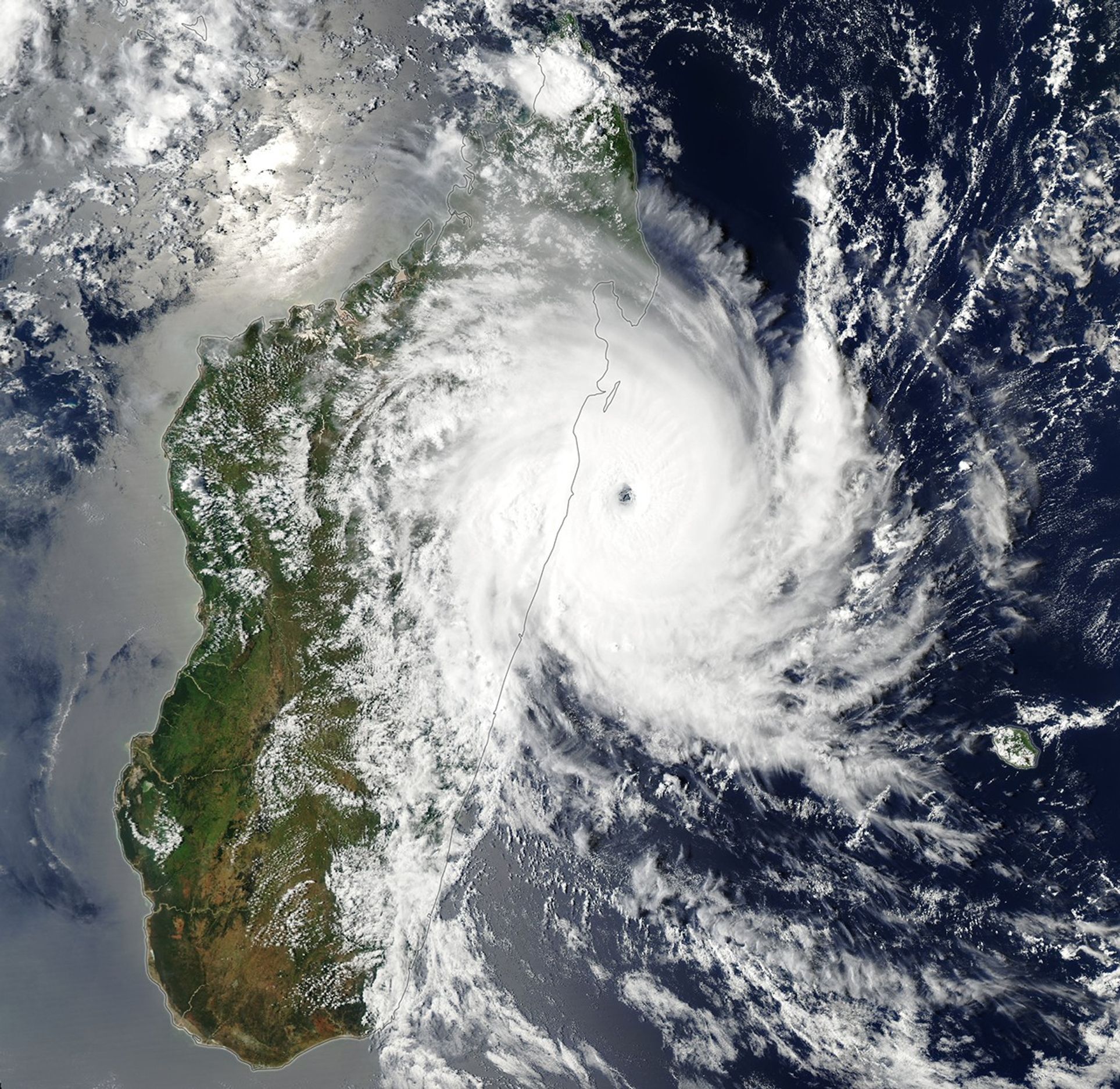
For the second time in two weeks, a powerful tropical cyclone struck Madagascar. On January 31, Fytia battered the remote northwestern coast of the island with destructive winds and torrential rains that displaced thousands of people. Less than two weeks later, Gezani made a direct hit on one of the island’s largest cities before sweeping past areas that Fytia had just flooded.
The MODIS(Moderate Resolution Imaging Spectroradiometer) on NASA’s Aqua satellite captured this image of Gezani as it neared Madagascar on February 10, 2026. At the time, the storm was undergoing rapid intensification. Its sustained winds peaked at 200 kilometers (125 miles) per hour before making landfall at Category 3 hurricane strength.
According to meteorologists with the Joint Typhoon Warning Center, the storm developed amid conditions “highly favorable” to strengthening, including sea surface temperatures above 28 degrees Celsius (82 degrees Fahrenheit), wind shear below 20 kilometers (12 miles) per hour, and an unusually moist atmosphere. As the storm passed near Toamasina, Madagascar’s second-largest city, satellites that contribute to NASA’s IMERG (Integrated Multi-satellite Retrievals for GPM) product measured rain rates up to 4 centimeters (1.6 inches) per hour.
The deluge caused widespread flooding in Toamasina and several other parts of the island. Preliminary damage assessments from Madagascar’s National Office for Risk and Disaster Management linked the storm to dozens of deaths, hundreds of injuries, and damage to more than 27,000 homes. Reports from news outlets and humanitarian groups described chaotic conditions in Toamasina, with widespread power outages, numerous collapsed roofs, and a lack of clean water.
January 29, 2026
February 14, 2026
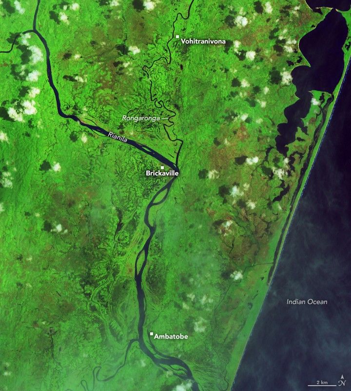
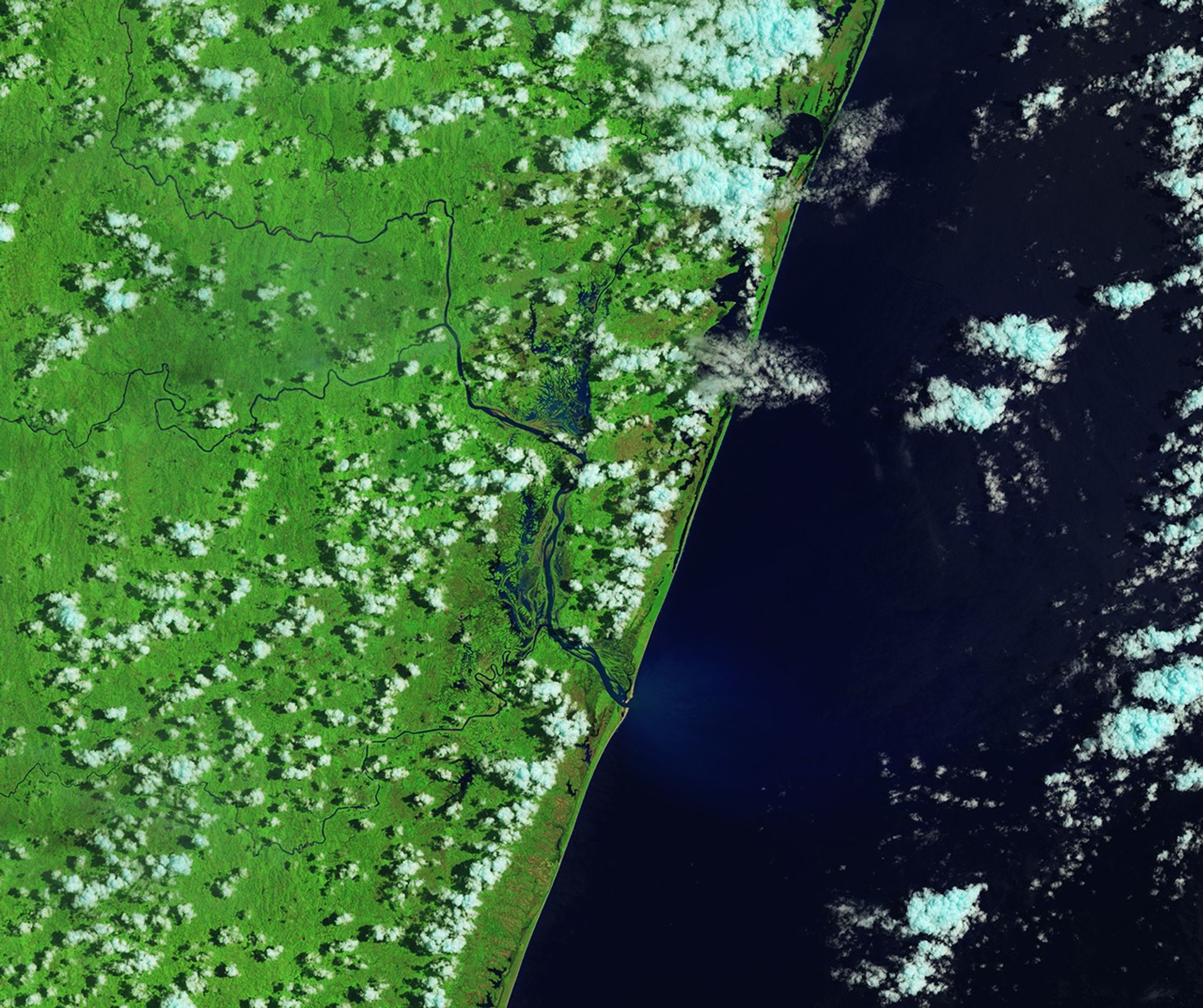
In this false-color image acquired before the flooding, the Rianila and Rongaronga rivers merge near the town of Brickaville. River water appears dark blue against a bright green background of farmland and savanna forest.
NASA Earth Observatory / Lauren Dauphin
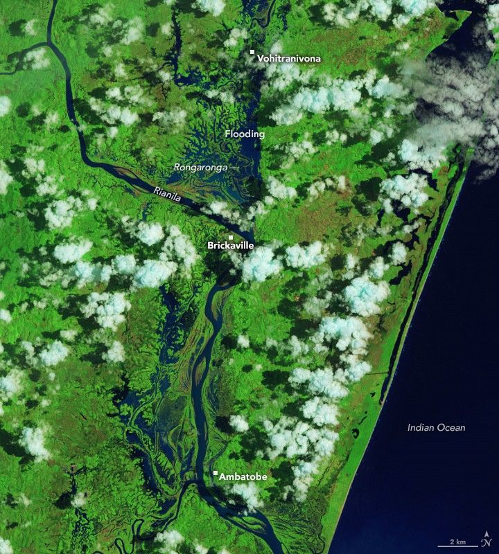
In a false-color image acquired after the flooding, waterways appear much wider, and floodwater covers large portions of the landscape west of the two rivers, both north and south of Brickaville.
NASA Earth Observatory / Lauren Dauphin
In this false-color image acquired before the flooding, the Rianila and Rongaronga rivers merge near the town of Brickaville. River water appears dark blue against a bright green background of farmland and savanna forest.
NASA Earth Observatory / Lauren Dauphin
In a false-color image acquired after the flooding, waterways appear much wider, and floodwater covers large portions of the landscape west of the two rivers, both north and south of Brickaville.
NASA Earth Observatory / Lauren Dauphin
January 29, 2026
February 14, 2026
Before and After
January 29, 2026 – February 14, 2026
The OLI (Operational Land Imager) on Landsat 8 captured this false-color image of severe flooding near Brickaville, just south of Toamasina, on February 14, 2026 (right). For comparison, the left image shows the same area before the storm. Villages and farmland along the Rongaronga River appear particularly hard hit. Crops commonly grown in this area include rice, vanilla, lychees, black pepper, cloves, and cinnamon, according to researchers from the French Agricultural Research Centre for International Development.
Madagascar is one of the most cyclone-prone countries in Africa, with about six storms typically affecting the island each year and two making direct landfall. The cyclone season generally runs from November through April, with peak activity between January and March.
In an abandoned cemetery on Cuba’s Isla de la Juventud stands the weathered headstone of Estefania Koenig. When she died in 1981, at the ripe old age of 95, she was the last American of what had once been called the McKinley Colonies. A century ago, it was a thriving citrus-growing community, American in everything except the letter of the law. Then came a couple of devastating hurricanes — and the closure of a geopolitical loophole.
A forgotten footnote in American history
The story of the McKinley Colonies is more than a forgotten footnote in history. William McKinley, the 25th president of the United States (from 1897 until his assassination in 1901), was America’s last unabashed expansionist-in-chief. Under his watch, the U.S. snapped up Guam, the Philippines, Puerto Rico, and Cuba from Spain (with full sovereignty over the former three and only temporary control over the latter).
McKinley matters today because the current occupant of the White House is a fan: Trump name-checked him in his second inaugural address, and his own musings about acquiring the Panama Canal, Canada, and Greenland suggest an urge to outdo McKinley’s territorial haul. Yet as the failed Cuban experiment shows, reality has a way of trumping even the most bullish dreams — pun very much intended.
The dilapidated American Cemetery near the site of the former colony of Columbia contains the remains of a few hundred settlers, including those of Estefania Koenig, the last American of the island, who died in 1981. (Credit: Isla de la Juventud)
At 934 square miles (2,419 km2), Isla de la Juventud is slightly smaller than Rhode Island, yet still the seventh-largest landmass in the Caribbean. It’s twice the size of Martinique, but with just over 80,000 inhabitants, it has barely one-fifth of its population. It lies just 29 miles (47 km) off Cuba’s southwest coast across the shallow Gulf of Batabanó — so shallow that a healthy cow could swim across at low tide, a rather unorthodox legal argument for Cuban ownership once claimed.
1940s map of the Isle of Pines, with the most prominent American towns on the island circled in red. Note the elevation and swamp separating the more hospitable north from the empty south. Jacksonville, on the southwest coast, was not settled by Americans but by so-called Caimaneros, English-speaking migrants from the Cayman Islands and Jamaica. The town is now known as Cocodrillo. (Credit: F.A. Carlson: American Settlement in the Isla de Pinos, Cuba – Ohio State University, 1942 / Colorization by Ruland Kolen)
The Island of the 500 Murders
Over the centuries, the island has had many identities and many names: Siguanea, Camaraco, or Ahoa to indigenous groups; La Evangelista to Columbus, who sighted it on his second voyage to the New World in 1494; Parrot Island for its flamboyant birdlife; and Treasure Island for its popularity as a pirate hideout. (It is rumored to have inspired Robert Louis Stevenson’s eponymous adventure story.)
In the 20th century, it acquired grimmer monikers — Island of the Deported, Island of the 500 Murders — after the opening of the notorious Presidio Modelo prison. Its most enduring name throughout the centuries, however, was Isle of Pines — until Fidel Castro rebranded it Isle of Youth in 1978.
Orange harvest on the Isle of Pines, ca. 1909. (Credit: Histoirepostale83)
Under Spanish rule, the Isle of Pines was barely governed and thinly populated. The 1864 census tallied just 2,000 souls. The plot twist came after the 1898 Treaty of Paris, which ended the Spanish-American War.
Article I of the treaty handed Cuba over to U.S. oversight with the promise of eventual independence. Article II, however, granted the U.S. full sovereignty over Puerto Rico and “other islands” in the West Indies formerly held by Spain. Was the Isle of Pines, far larger and more distant than Cuba’s minor keys, one of those “other islands”?
The swimming-cow faction said no. The New York Times, too, scoffed at the idea, comparing the idea to exempting Long Island from U.S. treaties or Ireland from the U.K. (the latter comparison hasn’t aged well, to say the least).
Cartoon from the Boston Globe (28 May 1898) showing “expansionist” president McKinley posing as a waiter, presenting Uncle Sam with a rich menu of territories to gobble up. (Credit: The View from This Seat)
But U.S. land promoters said yes — and loudly. In 1901, they helped ram the Platt Amendment through Congress; later embedded in Cuba’s constitution, it left the island’s status “to future adjustment by treaty,” conveniently excluding it from Cuba’s new boundaries. Cue the land rush!
Manifest Destiny rebooted
Glossy brochures billed the place as a “Veritable Garden of Eden.” (Fine print: Hurricanes? What hurricanes?) With the Wild West frontier officially closed in 1890, this was Manifest Destiny rebooted — with palm trees substituting for sagebrush. Citrus beckoned: The soil and climate were ideal, and access to American markets was easy.
American investors and settlers flooded in. In 1900, just 10 Yanks lived on the Isle of Pines. A decade later, up to 5,000 had bought plots and around 2,000 had settled permanently — effectively doubling the island’s population.
Contemporary maps of some American colonies on the Isle of Pines, “the most exclusively American Community outside the Borders of the United States”. The island is strategically located in the “West Indies”, not Cuba. On the right: the town of McKinley, laid out on 660 acres with 2,040 building lots, and ten boulevards radiating from a large central plaza. To be developed later: Port McKinley, at the junction of the Nuevas and Del Medio Rivers, less than a mile upstream from the northern coast. (Credit: Boston Rare Maps)
Land companies scooped up vast tracts on the cheap from locals, subdivided them into neat grids, and flipped them at a tidy profit. They were bought by Americans eager to try a sunnier version of capitalism among the orange trees. Colonies popped up by the dozen, mostly in the north. (The swampy center and rocky south stayed stubbornly unproductive.)
Founded in 1902, Columbia was one of the first American towns. Eight years later, it had a hotel, general store, school, post office, and a wharf on the Jucaro River. Also in 1902, colonists from Buffalo founded McKinley, a not-so-subtle appeal to the expansionism of the president assassinated the previous year at the Pan-American Exposition in their hometown. The town would sprout an East and West McKinley and lend its name to the broader McKinley Colonies.
“American ministers preach from Protestant pulpits”
Other American outposts followed. Santa Barbara featured Nordic-style houses and, improbably, an art gallery. Los Indios became the nucleus of a burgeoning citrus empire, with a direct connection to New York. Even Nueva Gerona, the old Spanish center, acquired an Old Virginia Café and an American Club. Settlers read their own newspaper, The Isle of Pines Appeal.
Cover of a 1904 manual from the Tropical Development Company, issued to potential bondholders. It extols the natural richness of the island, and offers instructions on how to set up schools, churches, and cities. (Credit: Islavision / Colorization by Ruland Kolen)
By 1910, as author I.A. Wright observed, Americans were in the majority on the island:
“American money is not only the official but the actual currency of trade; the prevailing architecture outside the towns is American; American ministers preach from Protestant pulpits; American teachers preside over schools where American children congregate, and these schools are conducted in English.”
“American spring wagons and automobiles have replaced the clumsy ox-cart and the picturesque coach, and they travel over the best of roads — wide, smooth highways, which facilitate shipments of fruits from orchards and gardens owned by Americans, producing for American markets. It is literally true that Americans own the Isle of Pines. Not two per cent of its area is the property of persons of other nationality.”
That sounds just about right. Another source states that, by 1925, Americans owned between 90% and 95% of the island, turning it into citrus central. One booster even published a 250-recipe cookbook for pineapples and grapefruit — as if gastronomic versatility was an argument for annexation.
The rudimentary plan for the town of West McKinley – only the inn has been laid out – plus surrounding plots, numbered and named for the Americans who bought them. (Credit: Carissa Pastuch / Library of Congress)
Optimists foresaw the full and swift Americanization of the island, de jure as well as de facto. But there was trouble in paradise. The devastating hurricanes of 1917 and 1926 didn’t read the brochures. America’s entry into World War I in 1917 diverted attention — and fertilizer — from the island. Many settlers lacked capital, know-how of tropical farming, or both.
A two-decade “slumber” in the Senate
Worst of all, the Hay-Quesada Treaty of 1903, which had “slumbered” in the U.S. Senate for over two decades, was finally ratified in 1925, confirming Cuban sovereignty over the Isle of Pines and slamming the annexation door shut.
The American dream withered. Most would-be colonists left. From its peak of about 2,000 settlers, the island’s American population plummeted to 276 in 1931, and just 150 year-rounders by 1942. Citrus acreage shrank from 4,000 to 1,000; ownership shifted to Brits and Canadians. A small but active Japanese colony became very successful in vegetable-growing.
Button from William McKinley’s 1900 campaign for a second term. The “colonies” in question are an earlier and broader concept than the ones discussed in this article. Here, they are understood to be all the territories gained in the Spanish-American war: Cuba, Puerto Rico, Guam, and the Philippines. Winning these colonies would bring prosperity to the country, McKinley’s campaign argued. And with success: he was easily re-elected – only to be assassinated four months later by Leon Czolgosz, an anarchist. (Credit: Busy Beaver Button Museum, Chicago)
A brief revival came in the 1950s under the dictatorship of Fulgencio Batista, who offered tax breaks to promote tourism on the island, which contrasted favorably with the vice, crime, and anti-Americanism of Havana and other hotspots on the Cuban mainland. But then came Castro.
In the mid-1950s, when they were still revolutionaries fighting Batista, Fidel Castro and his brother Raúl had done time in the Presidio Modelo, a panopticon prison for political enemies of the regime. After they ousted Batista in 1959, the Castros kept a close interest in the island, remaking it with youth camps, schools, and farms, and ultimately renaming it.
Lessons for Donald Trump
As with the rest of Cuba, what remained of American interests on the island was nationalized. By 1961, there were just 35 Americans left. By 1971, just one.
Government road on the Isle of Pines in 1910, near the height of the American colonization attempt. (Credit: postcard*depot)
President McKinley, as adept at raising tariffs as at raising flags, is an obvious example for his current successor. But do the failed McKinley Colonies hold any lessons for Donald Trump? Perhaps just this: Hype, hubris, and aggressive land grabs can redraw a map for a while. But geopolitical reality tends to catch up, as evidenced by those forgotten headstones in the Cementerio Americano.
Still, if recent patterns hold, one of these nights President Trump will tweet about that old Yankee grapefruit grove just off Cuba’s coast, declare it “rightfully American,” and demand an urgent return to its proper owners. Trump Colonies? It does have a certain ring to it …
Postcard of a typical American settler home on the Isle of Pines in the early 20th century. (Credit: TheCubanHistory / colorisation by Ruland Kolen)
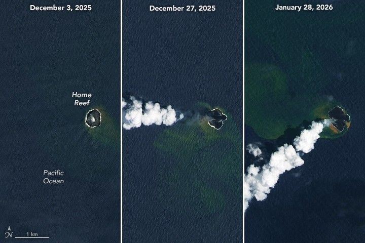
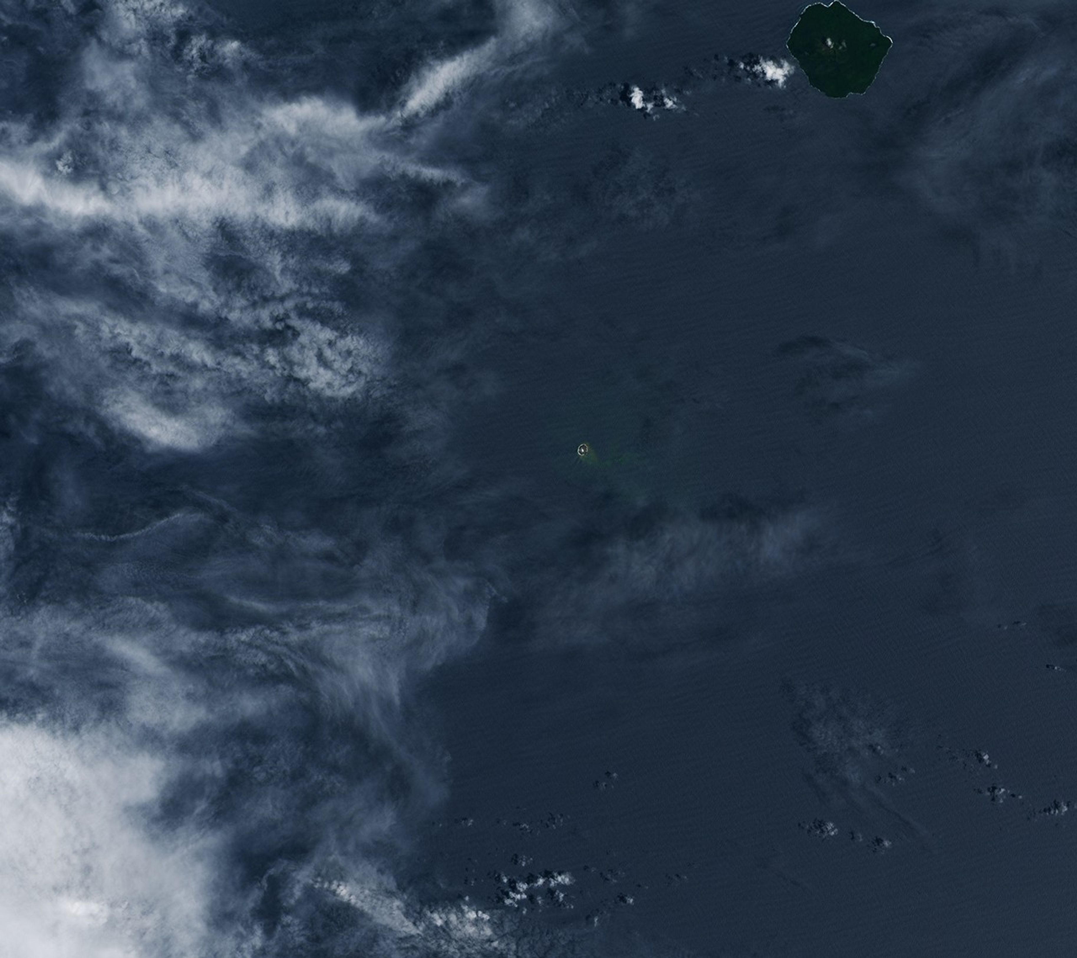
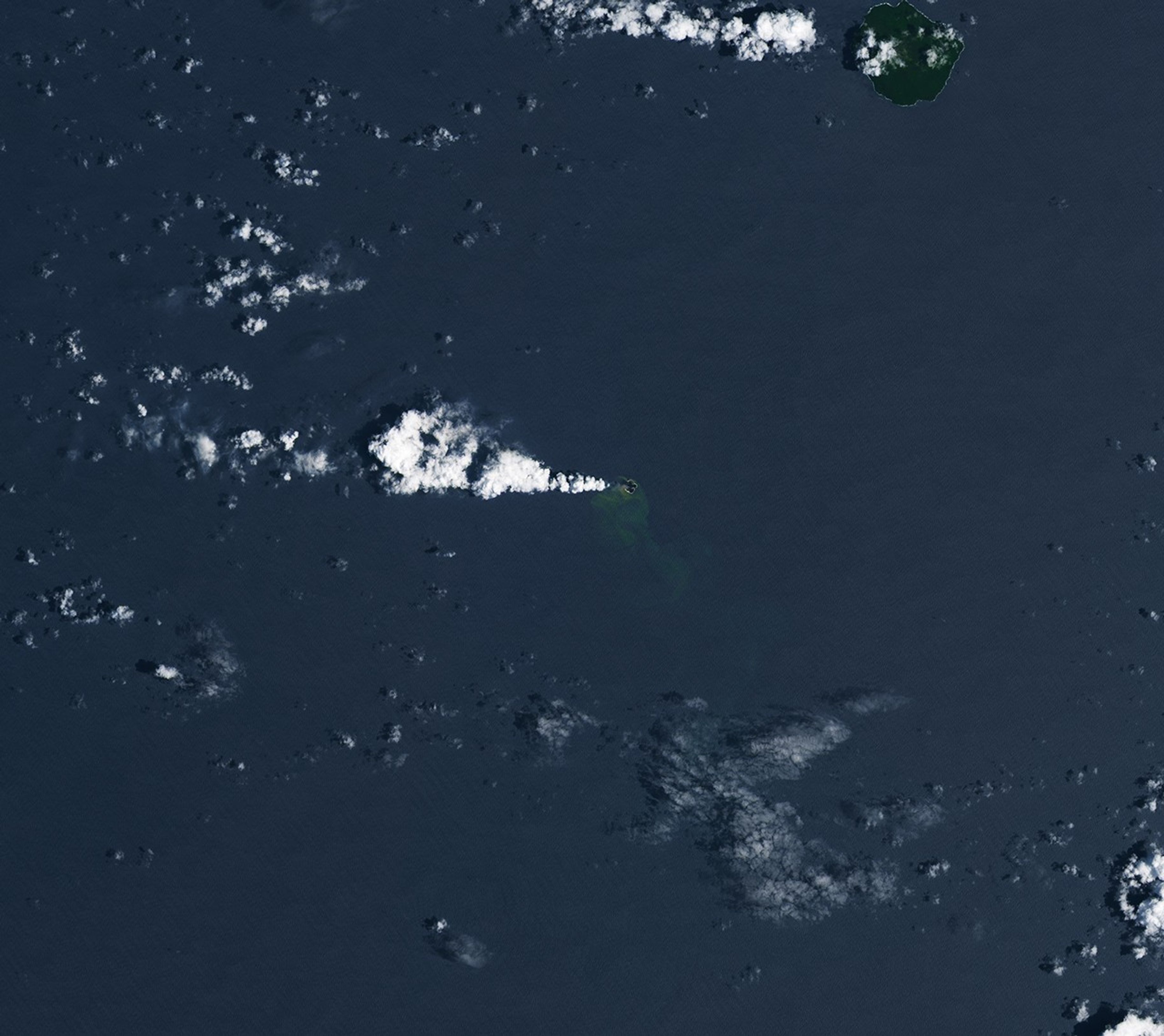
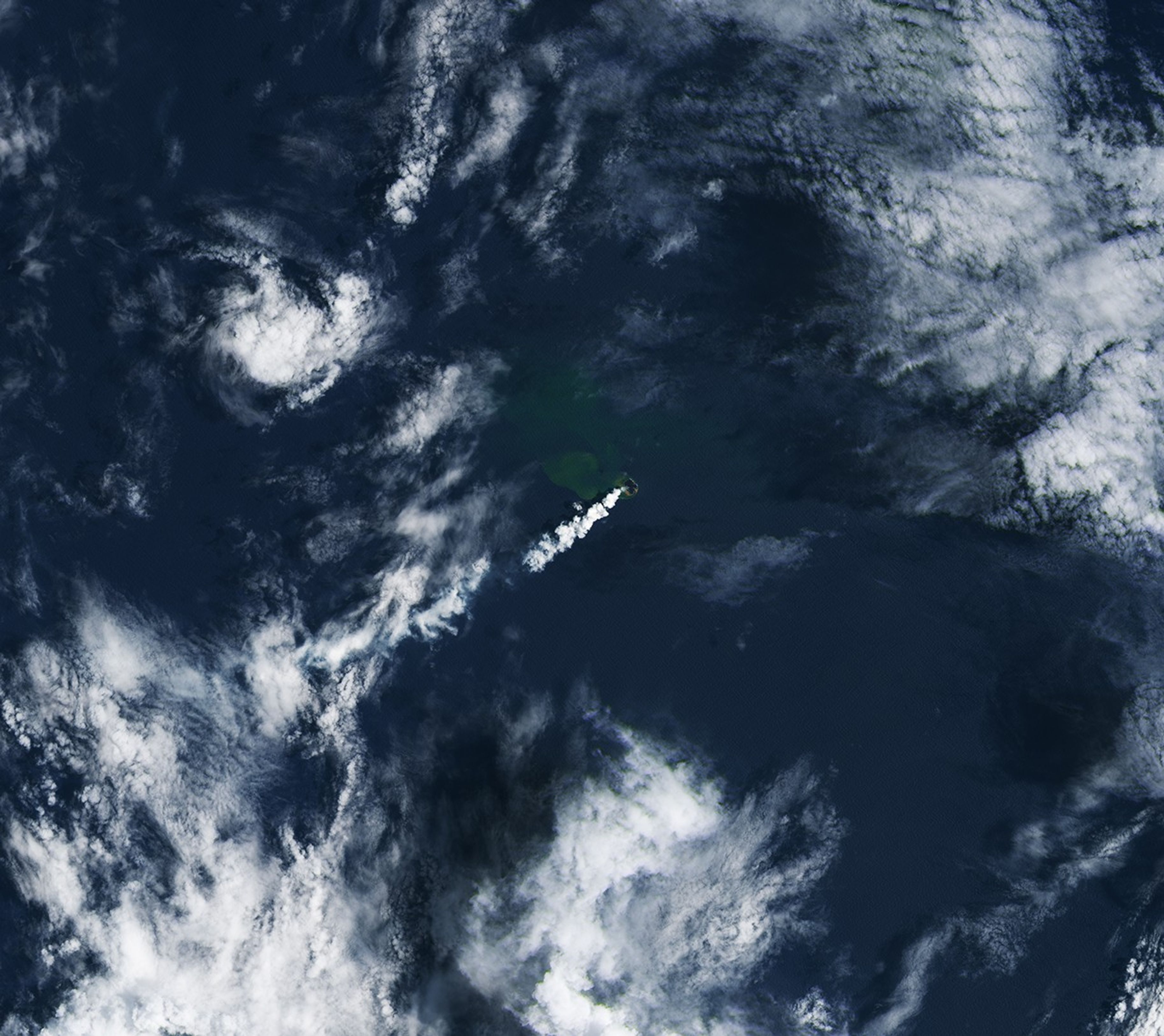
Home Reef, a mid-ocean volcano in the Tonga archipelago, continues to build onto its modest land area. Volcanic activity ramped up in December 2025, marking the latest in a series of periodic eruptions that began in 2022. The eruption was ongoing as of mid-February 2026.
Satellites are critical to monitoring volcanoes such as Home Reef in remote and difficult-to-access locations. These images, from December 3, 2025 (left), December 27, 2025 (center), and January 28, 2026 (right), captured some of the volcano’s growth during its recent spate of activity. They were acquired with the OLI (Operational Land Imager) on Landsat 8 and 9.
Thermal data from MODIS (Moderate Resolution Imaging Spectroradiometer) and VIIRS (Visible Infrared Imaging Radiometer Suite) indicate that this eruptive phase began on December 17, 2025, after about five months of quiet, said Simon Plank. Plank, a researcher at the German Aerospace Center (DLR), has been studying Home Reef’s eruption dynamics and cycles of growth and erosion since it awoke in 2022 and emerged above sea level.
Beginning in December 2025, lava flows first extended the island’s footprint to the east and south, then to the northwest, and later to the north. Based on synthetic aperture radar data from DLR’s TerraSAR-X satellite, the island had grown by nearly 8 hectares (20 acres)—about the size of 15 American football fields—by early February, Plank said.
Plumes of volcanic gases billowed from a 100-meter-diameter vent throughout the eruptive period. Pilots in the area observed plumes increasing in height during the last week of January, Tonga Geological Services reported, and the agency raised the aviation color code to orange due to the possible presence of suspended ash.
The discolored water around the island is a sign of gases and magmatic fluids venting from the volcano. Previous research has shown that such plumes of superheated, acidic water can contain particulate matter, volcanic rock fragments, and sulfur, and that they can appear before signs of an eruption above the surface. Concentrations of yellow sulfur mixing with the blue ocean may account for the water’s greenish appearance.
Home Reef is part of the Tonga Volcanic Arc, a line of submarine and island volcanoes along the Tonga-Kermadec subduction zone. One of its neighbors, Hunga Tonga-Hunga Ha’apai, produced one of the most powerful volcanic eruptions in recent history—large enough to send a volcanic plume into the mesosphere. The current activity at Home Reef is much tamer; officials say it poses low risk to inhabited islands nearby.
NASA Earth Observatory images by Lauren Dauphin, using Landsat data from the U.S. Geological Survey. Story by Lindsey Doermann.
Downloads
December 3, 2025
JPEG (5.01 MB)
December 27, 2025
JPEG (6.41 MB)
January 28, 2026
JPEG (5.40 MB)
References & Resources
Global Volcanism Program (2026) Home Reef. Accessed February 12, 2026.