Home Reef Adds On

Feb. 17th, 2026 05:01 am
[syndicated profile] earthobservatory_iod_feed

Posted by Lauren Dauphin

Three panels show the small volcanic island of Home Reef on different dates in December 2025 and January 2026. In each image from left to right, the island appears slightly larger, and plumes of volcanic gases and greenish, discolored water are more pronounced.
December 3, 2025 – January 28, 2026

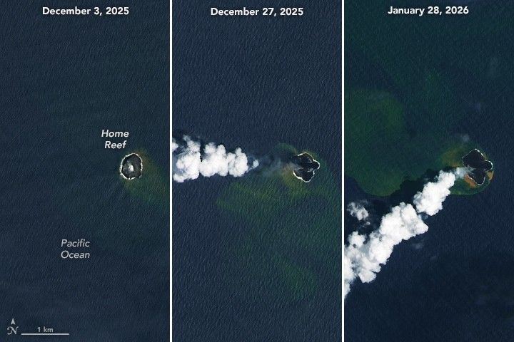
Home Reef, a mid-ocean volcano in the Tonga archipelago, continues to build onto its modest land area. Volcanic activity ramped up in December 2025, marking the latest in a series of periodic eruptions that began in 2022. The eruption was ongoing as of mid-February 2026.

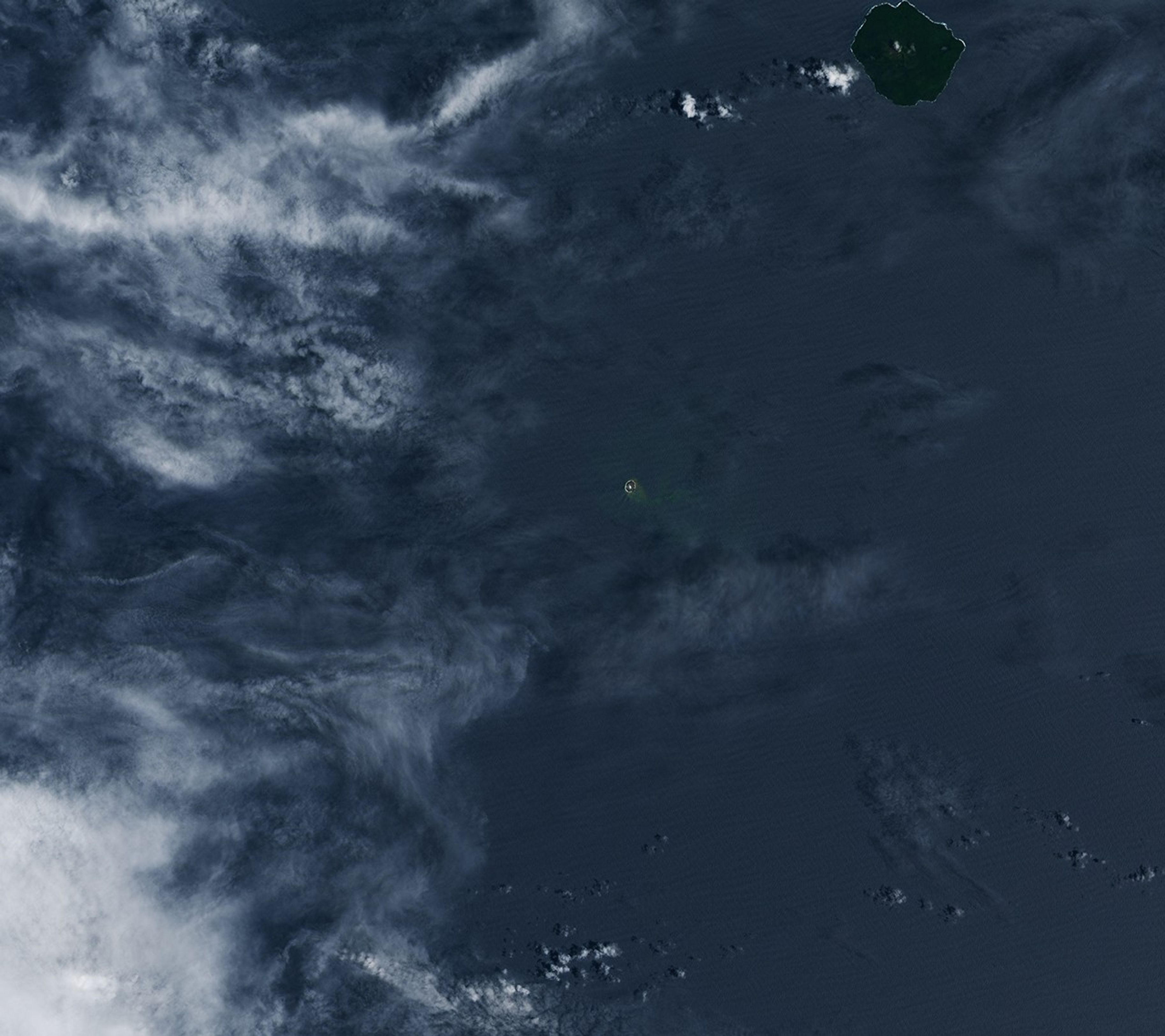
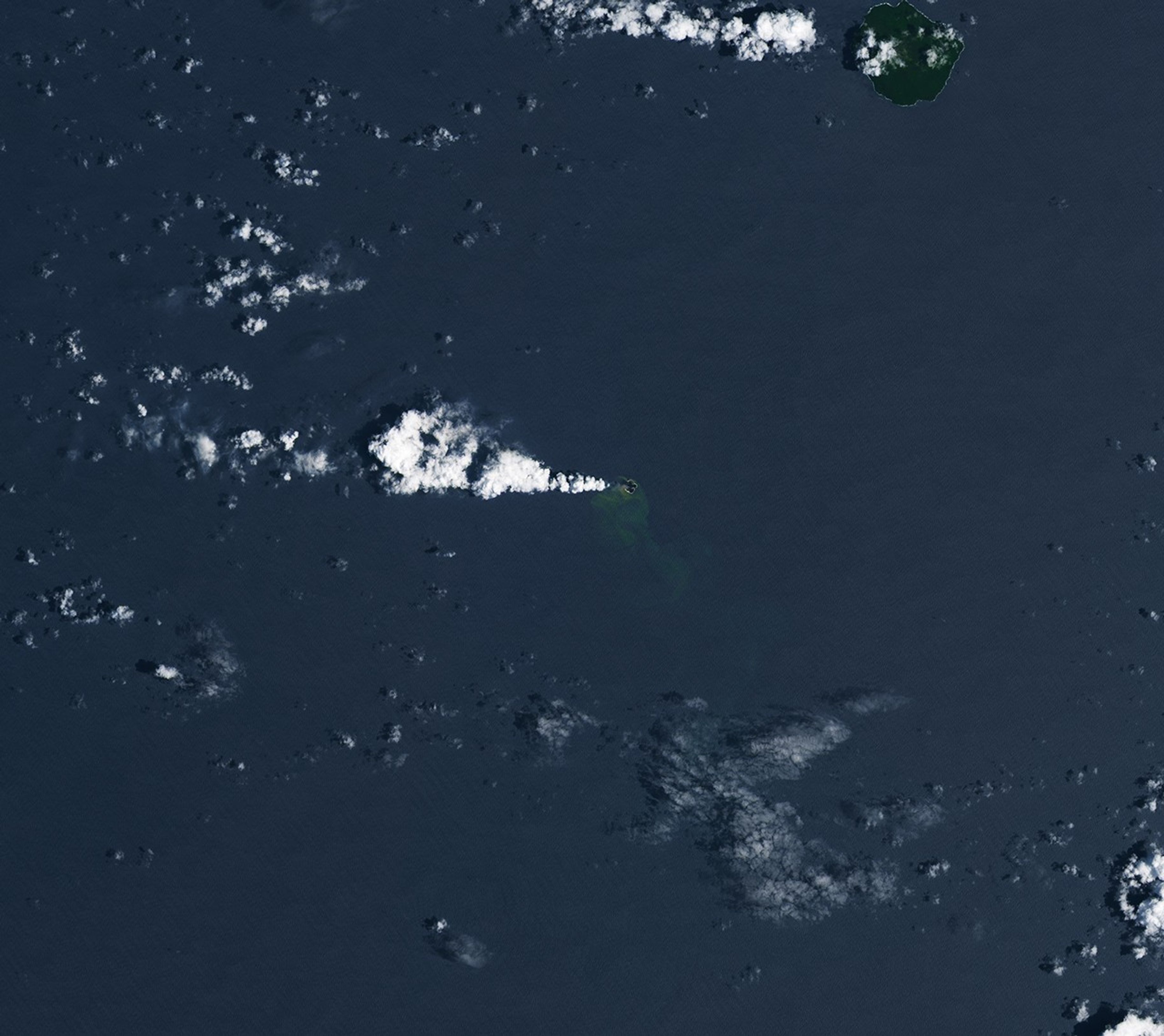
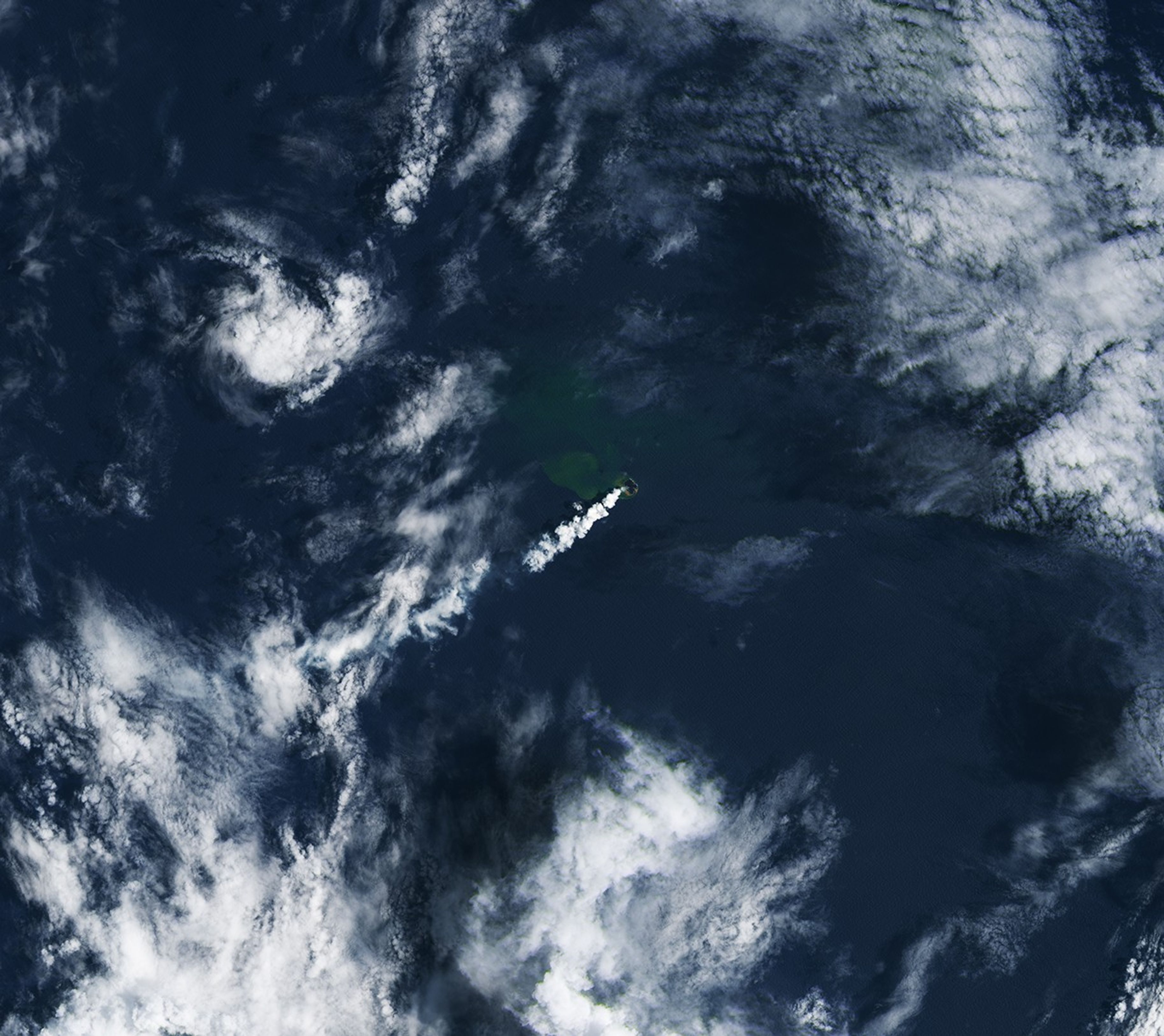
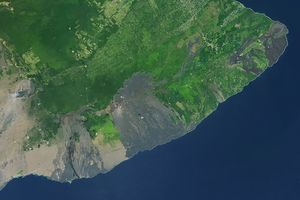
Satellites are critical to monitoring volcanoes such as Home Reef in remote and difficult-to-access locations. These images, from December 3, 2025 (left), December 27, 2025 (center), and January 28, 2026 (right), captured some of the volcano’s growth during its recent spate of activity. They were acquired with the OLI (Operational Land Imager) on Landsat 8 and 9.

Thermal data from MODIS (Moderate Resolution Imaging Spectroradiometer) and VIIRS (Visible Infrared Imaging Radiometer Suite) indicate that this eruptive phase began on December 17, 2025, after about five months of quiet, said Simon Plank. Plank, a researcher at the German Aerospace Center (DLR), has been studying Home Reef’s eruption dynamics and cycles of growth and erosion since it awoke in 2022 and emerged above sea level.

Beginning in December 2025, lava flows first extended the island’s footprint to the east and south, then to the northwest, and later to the north. Based on synthetic aperture radar data from DLR’s TerraSAR-X satellite, the island had grown by nearly 8 hectares (20 acres)—about the size of 15 American football fields—by early February, Plank said.

Plumes of volcanic gases billowed from a 100-meter-diameter vent throughout the eruptive period. Pilots in the area observed plumes increasing in height during the last week of January, Tonga Geological Services reported, and the agency raised the aviation color code to orange due to the possible presence of suspended ash.

The discolored water around the island is a sign of gases and magmatic fluids venting from the volcano. Previous research has shown that such plumes of superheated, acidic water can contain particulate matter, volcanic rock fragments, and sulfur, and that they can appear before signs of an eruption above the surface. Concentrations of yellow sulfur mixing with the blue ocean may account for the water’s greenish appearance.

Home Reef is part of the Tonga Volcanic Arc, a line of submarine and island volcanoes along the Tonga-Kermadec subduction zone. One of its neighbors, Hunga Tonga-Hunga Ha’apai, produced one of the most powerful volcanic eruptions in recent history—large enough to send a volcanic plume into the mesosphere. The current activity at Home Reef is much tamer; officials say it poses low risk to inhabited islands nearby.

NASA Earth Observatory images by Lauren Dauphin, using Landsat data from the U.S. Geological Survey. Story by Lindsey Doermann.

References & Resources

You may also be interested in:

Stay up-to-date with the latest content from NASA as we explore the universe and discover more about our home planet.

Krasheninnikova Remains Restless
3 min read

The volcano on Russia’s Kamchatka Peninsula continues to erupt after centuries of quiescence.

Article
Hayli Gubbi’s Explosive First Impression
4 min read

In its first documented eruption, the Ethiopian volcano sent a plume of gas and ash drifting across continents.

Article
A Hot and Fiery Decade for Kīlauea
6 min read

The volcano in Hawaii is one of the most active in the world, and NASA tech makes it easier for…

Article

The post Home Reef Adds On appeared first on NASA Science.

[syndicated profile] snopes_feed

Posted by Nur Ibrahim

The files do contain references to cannibalism and ritualistic sacrifice, but they are not linked to DeGeneres.
[syndicated profile] snopes_feed

Posted by Jordan Liles

A Facebook page manager explained the exact text prompt they submitted to Grok, the AI tool that generated the inauthentic image.
[syndicated profile] snopes_feed

Posted by Anna Rascouët-Paz

The claim spread after the Trump administration revoked a scientific finding that carbon dioxide and other greenhouse gases threaten public health.
[syndicated profile] snopes_feed

Posted by Laerke Christensen

One social media user dared "someone" to say a photo didn't show Trump. We took up the challenge.

Surveying Popes Creek

Feb. 16th, 2026 05:01 am
[syndicated profile] earthobservatory_iod_feed

Posted by Michala Garrison

A satellite image centered on the area George Washington was born features a dusting of white snow on farmland, shallow tidal streams along the Potomac River, and green patches of forest.
January 19, 2026

George Washington spent much of his life at Mount Vernon, his beloved estate in Virginia overlooking the Potomac River, but that is not where life began for America’s first president. He was born on February 22, 1732, about 80 miles (130 kilometers) to the south in Westmoreland County, in a brick house along Popes Creek.

Though mid-February is typically chilly in Westmoreland County, signs of spring had started to emerge across the swampy, rolling lands held by the family when Washington was born. The birth, according to a brief note in the Washington family Bible, occurred around 10 a.m. on a day when the jasmine and jonquils had begun to bloom.

The OLI (Operational Land Imager) on Landsat 8 captured this scene of the lands west of Popes Creek—now the site of the George Washington Birthplace National Monument—on January 19, 2026. While the home where Washington was born sat just a few hundred feet from Popes Creek, lands owned by the Washington family extended northwest toward Mattox Creek. The family’s burial ground lies in the center of the image along Bridges Creek, where dozens of relatives are interred, including Washington’s parents, grandparents, and great-grandparents on his father’s side.

Washington’s time at Popes Creek was brief, and the historical record detailing his time there is limited. What is known, however, is that before his parents moved the family to Mount Vernon, he spent his first three-and-a-half years living on farmland in an area first settled by his great-great-grandfather in 1657. Archaeological evidence indicates that Native Americans used the land to hunt game and the area’s streams and rivers to harvest oysters and fish for shad and herring prior to the arrival of Europeans. George Washington’s father used the land to manage a plantation and, with a few dozen enslaved people, raised tobacco and tended a kitchen garden with herbs, fruits, and vegetables.

After the family’s move to Mount Vernon, Washington made occasional visits to Popes Creek. Historians think that during one of these, he made an early attempt at land surveying, an activity that would later become his occupation. Below is an image of what is likely one of his first surveying maps, drafted when he was a teenager, depicting the lands around Popes Creek. The map accurately represents the location of several key waterways, including Mattox Creek, Bridges Creek, and Popes Creek. Both Mattox Creek and Popes Creek are tidal tributary streams of the Potomac, meaning their flow is influenced by the ebb and flow of ocean tides.

A photo features two maps that illustrate the birthplace of George Washington in Westmoreland County, Virginia. The upper map is believed to have been created by Washington himself in 1747. The lower map is a modern rendition. Both maps show significant geographic features such as Popes Creek and Bridges Creek.
1747

By the age of 17, Washington had been named the official surveyor of nearby Culpeper County. He completed 199 surveys within three years, covering more than 60,000 acres (24,000 hectares), according to the Mount Vernon Ladies’ Association. He also conducted surveys on Virginia’s western frontier in Frederick and Hampshire counties. Historians credit the backcountry and mapmaking skills he gained as a land surveyor with playing an important role in his military career during the French and Indian War and ultimately helping launch his rise to general and commander-in-chief during the Revolutionary War and, eventually, to the U.S. presidency.

NASA Earth Observatory image by Michala Garrison, using Landsat data from the U.S. Geological Survey. Map courtesy of the David Rumsey Map Collection, David Rumsey Map Center, Stanford Libraries. Story by Adam Voiland.

References & Resources

You may also be interested in:

Stay up-to-date with the latest content from NASA as we explore the universe and discover more about our home planet.

Cooper Creek Replenishes Lake Eyre
3 min read

Another major tributary reached the Australian outback lake in 2025, extending the months-long flood of the vast, ephemeral inland sea.

Article
Australia’s Howick River
2 min read

Winding across the Jeannie catchment in northern Queensland, the river sustains diverse ecosystems on its way to the Coral Sea.

Article
Pacific Moisture Drenches the U.S. Northwest
3 min read

A potent atmospheric river delivered intense rainfall to western Washington, triggering flooding and mudslides.

Article

The post Surveying Popes Creek appeared first on NASA Science.

[syndicated profile] snopes_feed

Posted by Jordan Liles

The "pizza" references in the Epstein files that social media users highlighted have innocuous explanations.
[syndicated profile] snopes_feed

Posted by Joey Esposito

The advertisement appeared to be an example of “culture jamming,” an anti-capitalist movement that grew in popularity in the 1990s.
[syndicated profile] snopes_feed

Posted by Emery Winter

The data repeatedly shows that transgender people aren't more likely to commit mass shootings than any other groups of people in the U.S.
[syndicated profile] snopes_feed

Posted by Taija PerryCook

Bondi's DOJ tenure has given rise to widespread misinformation — much of it directed at the attorney general herself.
[syndicated profile] snopes_feed

Posted by Aleksandra Wrona

In February 2026, social media users resurfaced an AI-generated video that animated an authentic image and inserted minors who were not present.
[syndicated profile] snopes_feed

Posted by Jack Izzo

Investigating the claim was difficult because the unofficial subreddit for agents, from where the rumor was said to emerge, was set to private.
[syndicated profile] snopes_feed

Posted by Jack Izzo

The president didn't share the post in question — and the idea behind it isn't backed by science.
[syndicated profile] snopes_feed

Posted by Taija PerryCook

AI-generated or otherwise altered images of the U.S. president swirled online as more files regarding late sex offender Jeffrey Epstein emerged.
[syndicated profile] snopes_feed

Posted by Emery Winter

The photo was of a woman entirely unrelated to the shooting. Her mother has reportedly said she's "afraid to go outside."

Profile

greenette: (Default)
rantaro a.

February 2026

S M T W T F S
1234567
891011121314
15161718192021
22232425262728

Page Summary

Style Credit

Expand Cut Tags

No cut tags
Page generated Feb. 23rd, 2026 07:24 pm
Powered by Dreamwidth Studios